
Damage and Wind Strength of Hurricanes
The Destructive Capacity of the Very Strong Winds of Hurricanes, Cyclones and Tropical Storms
What are cyclones hurricanes and typhoons? how they are formed and strengthened by rising hot air. We look at the different categories and the ways of measuring their strength, wind speeds and the amount of damage you can expect.
In a world where climate change is starting to dramatically increase the frequency and size of storms and the amount of rainfall they produce, it becomes ever more important to understand them and how we can protect ourselves from them.
See also:
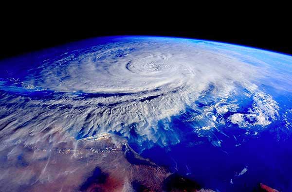 A Cyclone building to the North of Australia
What are Cyclones, Hurricanes and Typhoons?
Cyclones, Typhoons and Hurricanes are effectively the same thing. They are formed by hot air. They develop when sea water temperatures rise (usually in spring and summer) to above 26.5 Degrees celsius. Hot air rises taking evaporated sea water with it and as it rises higher in the atmosphere it cools, the water condenses out forming rain and the action of condensation releases heat which further fuels the cyclone. The rising column of air causes a reduction in air pressure in the centre which draws air into the bottom of the cyclone further increasing the rate of evaporation of the sea water, the storm progressively increases in intensity.
The Coriolis effect, tropical storms and water down the plug hole
The turning of the earth starts the rising air rotating, in the northern hemisphere tropical storms are called Typhoons or Hurricanes and turn in an anticlockwise direction while in the southern hemisphere they are called Cyclones and turn clockwise. This turning motion (just like your bathwater going down the plughole) is known as the Coriolis effect after a man called Gaspard Gustave Coriolis who wrote a mathematical paper about the effect in 1835.
Where do Tropical storms form?
Tropical storms need to form more than 5 degrees of latitude away from the equator (Bali is 8 degrees south) for the Coriolis effect to start the winds circulating. Most tropical storms form between 10 and 30 degrees away from the equator with 87% forming no more than 20 degrees away from the equator.
Tropical storms move in a westerly direction and, in the absence of strong winds, tend to move towards the poles (South in the southern hemisphere). They drift around for a while (up to 30 days) until they hit land and then the absence of warm sea water makes them collapse.
How large can they get?
They can get frighteningly large, never underestimate the strength of a tropical storm. The most intense storm on record was Typhoon Tip which hit the North Western Pacific Ocean in 1979 with sustained wind speeds of up to 310 km/h (190 mph). Tip was also the largest on record covering an area 2,170 kilometres (1,350 miles) in diameter.
In the Southern hemisphere the tropical cyclone season runs from November 1 until the end of April, with peaks in mid-February to early March.
Historically storm surge (rise in sea level) has caused 90% of fatalities from tropical storms.
There are different scales used in different parts of the world to categorise tropical storms.
In Indonesia we use the Australian region tropical cyclone intensity scale although if a tropical storm forms north of 10 degrees south and between 90 degrees and 125 degrees East then it comes under the jurisdiction of the Jakarta, Tropical Cyclone Warning Centre (TCWC) and is called a Tropical Depression. Once it hits 34 knots it is categorised as a tropical cyclone and is given a name.
The Beaufort Scale and the damage you can expect
The stronger the wind the more damage it can cause. In 1805 a sailor by the name of Rear Admiral Francis Beaufort developed the Beaufort scale to quantify the effects of different wind speeds as follows:
| Beaufort Scale |
Descripn | Wind Speed |
Wave Height |
TNT Equivalent |
TNT Equivalent |
|---|---|---|---|---|---|
| 0 | Calm | <1 km/h | 0m | Sea like a mirror | Smoke rises vertically. |
| 1 | Light air | 1-5 km/h | 0-0.2 m | Ripples without foaming crests | Smoke drifts but will not turn weather vanes. |
| 2 | Light Breeze | 6-11 km/h | 0.2-0.5 m | Small short wavelets, crests do not break | Face can feel the wind, leaves rustle, weather vanes move. |
| 3 | Gentle Breeze | 12-19 km/h | 0.5-1 m | Large wavelets, crests begin to break, occasional white horse | Leaves and twigs constantly moving, small flags extend. |
| 4 | Moderate Breeze | 20-29 km/h | 1-2 m | Small waves, frequent white horses | loose paper and dust raised, small branches move. |
| 5 | Fresh Breeze | 30-39 km/h | 2-3 m | Moderate longer waves, many white horses | Small trees with leaves begin to sway, crested wavelets on inland waters. |
| 6 | Strong Breeze | 40-49 km/h | 3-4 m | Larger waves start, extensive white foam crests, some spray | Large branches move,telephone wires whistle, umbrellas difficult to handle. |
| 7 | High wind | 50-61 km/h | 4-5.5 m | Sea starts to pile up, white foam starts to blow in streaks along waves. | Whole trees in motion, not easy to walk into wind. |
| 8 | Gale | 62-74 km/h | 5.5-7.5 m | Moderately high waves, crests break into spindrift, foam blown into streaks in direction of wind. | twigs get broken off, walking difficult. |
| 9 | Severe Gale | 75-89 km/h | 7-10 m | High waves, dense streak of faom, sea begins to roll, spray starts to restrict visibility. | Some structural damage, chimney pots and roof slates removed. |
| 10 | Storm | 90-104 km/h | 9-12.5 m | Very high waves, overhanging crests, surface of heavily rolling sea generally white, visibility impaired. | Trees uprooted, structural damage to buildings. |
| 11 | Violent storm | 105-119 km/h | 11.5-16 m | Very high waves, medium ships disappear into waves, edges of waves blown into foam, limited visibility. | Widespread serious damage. |
| 12 | Hurricane force | >120 km/h | >14 m | Air filled with foam and driving spray, sea completely white, very limited visibility. | Catastrophic damage. |
Categories of cyclones and hurricanes, wind strengths and damage to be expected
So what can we expect from a Cyclone? Well here’s a bit of a summary:
Tropical Depression (Tropical Low in Australia)
- Sustained windspeeds 0 to 63 km/h (0 to 34 knots) with gusts from 0 to 9 km/h (49 knots)
Tropical Cyclone category 1 (Tropical storm in the Northern hemisphere)
- Sustained windspeed 64 to 88 km/h (34 to 47 knots) with gusts from 91 to 124 km/h (50 to 67 knots)
- Damage to be expected - Minimal
- Damage mostly restricted to trees, shrubbery and lightweight structures; no substantial damage to other structures; some damage to poorly constructed signs.
- In coastal areas some road flooding and minor damage to jetties and piers.
Tropical Cyclone category 2 (Tropical storm in the Northern hemisphere)
- Sustained windspeed 89 to 117 km/h (48 to 63 knots) with gusts from 125 to 164 km/h (68 to 89 knots)
- Damage expected - Moderate
- Considerable damage to tree and shrubbery foliage, some trees blown down; extensive damage to poorly constructed signs and some damage to windows, doors and roof materials, but no major destruction to buildings. Coastal roads and low-lying escape routes inland cut off by rising water about two to four hours before landfall; considerable damage to jetties and piers, marinas flooded; small craft in protected anchorages torn from moorings.
Severe Tropical Cyclone category 3 (Typhoon or Hurricane category 1 and 2 in the N hemisphere)
- Sustained windspeed 118 to 159 km/h (64 to 85 knots) with gusts from 165 to 224 km/h (90 to 121 knots)
- Damage to be expected - Extensive
- Foliage torn from trees; large trees blown down; poorly constructed signs blown down; some damage to roofing, windows, and doors; some structural damage to small buildings.
- Serious flooding in coastal areas; many small structures near the coast destroyed; larger coastal structures damaged by battering waves and floating debris.
- Low-lying escape routes inland cut off by rising water about three to five hours before landfall; flat terrain 1 metre or less above sea level flooded up to 14 or more kilometres inland.
- Evacuation of low-lying residences near to shorelines may be required.
Severe Tropical Cyclone category 4 (Typhoon or Hurricane category 3 and 4 in the N hemisphere)
- Sustained windspeed 160 to 200 km/h (86 to 107 knots) with gusts from 225 to 279 km/h (122 to 151 knots)
- Damage to be expected - Extreme
- Shrubs, trees, and all signs blown down; extensive damage to roofs, windows, and doors, with complete failure of roofs on many smaller residences.
- Flat terrain 3 metres or less above sea level flooded as far as 10 kilometres inland; flooding and battering by waves and floating debris cause major damage to lower floors of structures near the shore; low-lying escape routes inland cut off by rising water about three to five hours before landfall; major erosion of beaches
- Massive evacuation of residences as far as 10 kilometres inland may be required.
Severe Tropical Cyclone category 5 (Super Typhoon or Major Hurricane category 4 or 5 in the N hemisphere)
- Sustained windspeed of more than 200 km/h (107 knots) with gusts greater than 279 km/h (151 knots)
- Damage to be expected - Catastrophic
- Trees, shrubs, and all signs blown down; considerable damage to roofs of buildings, with very severe and extensive damage to windows and doors; complete failure on many roofs of residences and industrial buildings; extensive shattering of glass in windows and doors; complete buildings destroyed; small building overturned or blown away.
- Major damage to lower floors of all structures less than 5 metres above sea level within 500 metres of the shore.
- Low-lying escape routes inland cut off by rising water about three to five hours before landfall; major erosion of beaches.
- Massive evacuation of residential areas on low ground as far inland as 18 kilometres may be required.
See also:
Phil Wilson
Copyright © Phil Wilson February 2012
This article, or any part of it, cannot be copied or reproduced without permission from the copyright owner.